 N-Ways
 N-Ways in Gabon
Find any place in Gabon.
Search a place or a business in Libreville, Port-Gentil or Franceville and N-Ways takes you to the door, in French or English. It prices taxis and fuel in F CFA, and plans the boat to Port-Gentil, which no road reaches from Libreville.



- Capital
- Libreville
- Money
- F CFA Central African CFA franc
- Clock
- WAT UTC+1, all year
- Drives on the
- Right
- Language
- French
- Petrol
- 595 F CFA A litre, set by the State
What works in Gabon
From the Estuaire to the Haut-Ogooué, on one map.
N-Ways speaks French when your phone does, menus and voice included, and you can switch to English in Profile. Here’s what you get on Gabon’s roads.
Search by name or Plus Code
Places, streets and businesses in all nine provinces. Gabon has no street postcodes (mail goes to a BP box), so search by the name of the place, or type a Plus Code to find any spot.
Turn-by-turn, in French or English
Spoken directions, lane arrows, road signs and the speed limit, with the province you’re in shown on the map, like “Estuaire · Gabon”.
Fair fares in F CFA
What a taxi or a shared taxi seat should cost in Libreville and beyond, from published fares, such as the fixed prices from Léon Mba airport.
Fuel in F CFA
Tell N-Ways your car once and every trip shows its litres and what they cost, at the pump price the State sets.
The boat to Port-Gentil
Choose Boat in Directions and N-Ways plans the way to the jetty, the crossing and the way on, with the weather where you board.
Help after a crash
N-Ways shows Gabon’s numbers to call as buttons: 1300 for the SAMU ambulance and 177 for police emergencies.
Main cities
The provincial capitals, from the coast to the forest. Search any of them, or a street or business inside.
- Libreville Estuaire
- Port-Gentil Ogooué-Maritime
- Franceville Haut-Ogooué
- Oyem Woleu-Ntem
- Lambaréné Moyen-Ogooué
- Mouila Ngounié
- Tchibanga Nyanga
- Makokou Ogooué-Ivindo
- Koulamoutou Ogooué-Lolo
Codes
A code for every compound, from Libreville to Franceville.
The name of your quarter or village and a number of at most five digits, unique in the whole country: Louis 12 01 leads a courier, a taxi or an ambulance to your gate. On a named street of Libreville the street comes first. Codes start provisional and are confirmed by the people who live there.
Open N-Ways at home, tap Get my code, and share it in one tap.
Get my code Read the research paper
For developers: look codes up, find the code at a point or decode them with the home codes API guide. No key is needed.
Host it yourself: every code, the areas, the engine and a ready-made server are open at github.com/n-ways/open-addresses-gabon, free to run on your own servers under their licences (data ODbL 1.0, engine Apache 2.0). Credit when you use it: N-Ways Addressing for Gabon, © N-WAYS LIMITED (nways.ng)
 Libreville
 to Port-Gentil
Gabon’s second city is a boat ride away.
No road links Libreville to Port-Gentil: you go by sea or by air. Choose Boat in Directions and N-Ways plans the crossing, the walk or ride to the jetty, and the way on when you land.
- Libreville–Port-Gentil: the national company CNNII announced a regular passenger and freight service on the Elobey VI in February 2026. No timetable is published, so times are estimates.
- Other crossings N-Ways knows include Port-Gentil–Omboué and Omboué–Lambaréné, and river ferries (bacs) on the road network.
- Safety first: every boat trip comes with a reminder to wear a life jacket and not to travel at night or in bad weather.
- On the road: the speed limit is 60 km/h in town and 110 km/h outside, and fill up in Libreville, Oyem, Lambaréné or Franceville before long legs inland.


Checked 18 October 2026. Sources: Wikipedia (Port-Gentil), Gabonreview (Elobey VI), Gabonactu (fuel prices), Gabon Media Time (airport taxis), WHO road safety profile, UK FCDO, IANA time zones.
Crossing into Gabon
From Cameroon at Eboro, on the road to Bitam and Oyem.
The main road from Yaoundé crosses the Ntem at Abang-Minko’o and Eboro. There is no joint post: you stop on each side. N-Ways puts the border in your steps, and the clock doesn’t change.
- Not ECOWAS: Gabon is in CEMAC. Non-CEMAC travellers need a passport and a visa for Gabon (an e-Visa or one from an embassy); the ECOWAS travel certificate isn’t valid.
- For the car, its papers and CEMAC insurance (the Carte rose); the ECOWAS Brown Card isn’t valid here.
- Bring a yellow fever card: Gabon asks every traveller aged 9 months or more for one.
Checked 18 October 2026. Sources: L’Union, Gabonreview (CEMAC), UK FCDO (entry), Carte rose, WHO (yellow fever).
What N-Ways does in Gabon
Every screen here is the real app in Gabon. Swipe through each row.
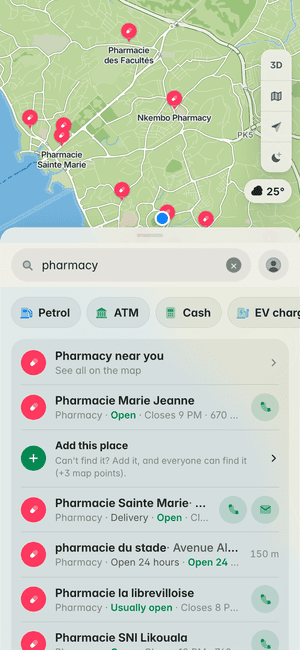
Find what’s near
Pharmacies around Libreville, with their opening hours.
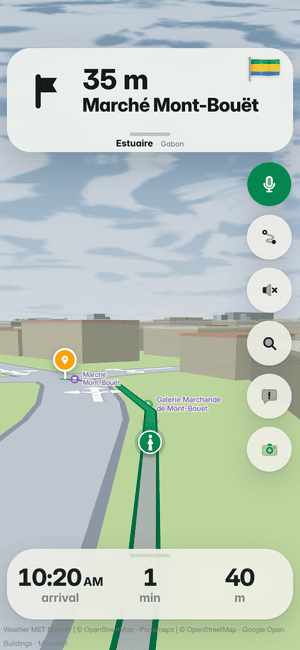
Right to the door
The last metres on foot, to the entrance of Marché Mont-Bouët.
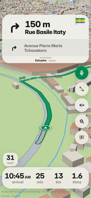
Turn-by-turn in Libreville
Every turn called with the street’s own name, on Libreville’s roads.
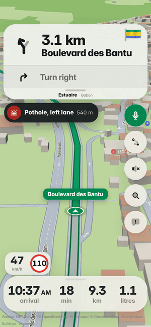
Potholes, lane by lane
Know which lane the pothole is in before you reach it, across Libreville.
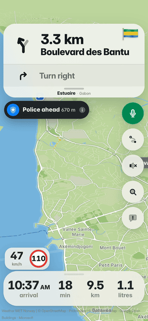
Police ahead
Other drivers’ reports warn you before a checkpoint in Libreville.
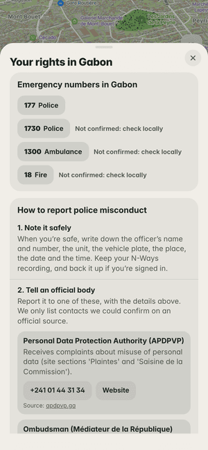
Your rights in Gabon
Gabon’s emergency numbers and where to report misconduct, one tap away.
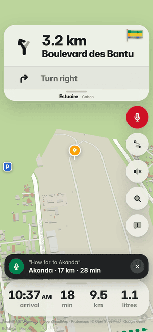
Ask while you drive
“How far to Akanda?” Tap the mic and ask, in English or French.
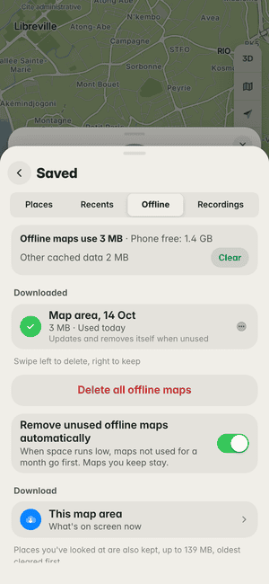
Maps without data
Save the Libreville map area once and it works with no signal.


What it fixes for you, free.
The everyday problems of getting around, and what N-Ways does about each. No subscription, no account needed.
“Call me when you reach the junction.”
Addresses that don’t exist on any map. Search a postcode, a digital address or a landmark, and N-Ways walks you to the door.
See howData finished halfway there.
Save the map for offline use and keep going with no signal. It tidies itself when storage is short.
See how
Works with Apple CarPlay.
Connect your iPhone and N-Ways opens on your car’s screen: the same map and voice as on the phone, with big buttons made for driving. A trip you started on the phone carries on in the car.


The next turn onto Ikorodu Road with its green road sign, fuel for the trip in litres and the arrival time.
The map turns dark when your car switches to night.
Each route’s time and distance before you set off, then Go.
Bad road ahead, in time to slow down.
Places, businesses and postcodes, picked from a list.
Look around, then one tap brings the map back to the car.
Shown on a drive in Lagos.
- Turn by turn
- The distance, the road’s name and its green sign, and on iOS 18 the lane to be in.
- Spoken directions
- Through the car’s speakers, turning your music down while it talks.
- Warned in time
- Potholes, bad road, crashes, traffic lights, tolls and borders ahead. “Still there?” takes one tap.
- Find your way there
- Places, businesses and addresses, or Home, Work and your recent trips.
- Pick your route
- Time and distance for each before you go, and a faster way offered on the road.
- Report from the wheel
- Crash, police, traffic, roadworks, hazard or closure, from six big buttons.
Part of the N-Ways app for iPhone. You need an iPhone and a car with CarPlay.
Also on iPhone, in testing: your next turn, the road sign and your lane on the Lock Screen and in the Dynamic Island.
Your trips, your data.
Your trips stay yours
We don’t sell where you go, and ads never get your trip history.
No account needed
Search and drive without signing in. Sign in only to keep places and points on another phone.
Recordings stay on your phone
A checkpoint video is never uploaded unless you choose to back it up.
Delete it all
Remove your account and everything in it at any time. Privacy policy
Building an app for Gabon?
The N-Ways Maps Platform: the maps, address search and routes behind the app, as APIs and SDKs for the web, Android and iOS. Free calls every month, then prices in your own currency.
Your business, on the road to it.
A short billboard shows to drivers heading your way, only when they’re stopped or slow, never near a turn. Pay for the days you choose.
Questions about N-Ways in Gabon
How do I find an address in Libreville?
Gabon has no street postcodes (mail goes to a BP box), so search by the name of the place, street or business, or type a Plus Code to find any spot. N-Ways covers all nine provinces, from Libreville and Port-Gentil to Franceville and Oyem.
Which language does N-Ways speak in Gabon?
French when your phone does, menus and voice included, and you can switch to English in Profile.
How much is a taxi in Libreville?
N-Ways shows what a taxi or a shared taxi seat should cost in Libreville and beyond, from published fares, such as the fixed prices from Léon Mba airport.
How much is petrol in Gabon?
595 F CFA a litre, set by the State. Tell N-Ways your car once and every trip shows its litres and what they cost.
Can you drive from Libreville to Port-Gentil?
No road links Libreville to Port-Gentil: you go by sea or by air. Choose Boat in Directions and N-Ways plans the way to the jetty, the crossing and the way on; the national company CNNII announced a regular service on the Elobey VI in February 2026, but no timetable is published, so times are estimates.
What number do I call after a crash in Gabon?
1300 for the SAMU ambulance and 177 for police emergencies. N-Ways shows both as buttons.
Is there a free GPS app that works offline in Gabon?
N-Ways is free, and it can save a city for when there’s no signal; maps you stop using tidy themselves away when your phone runs low on space. The map works in your browser at map.nways.ng.
How do I drive from Cameroon to Gabon?
The main road from Yaoundé crosses the Ntem at Abang-Minko’o and Eboro, on the way to Bitam and Oyem; there is no joint post, so you stop on each side. Gabon is in CEMAC: non-CEMAC travellers need a passport and a visa, the car needs CEMAC insurance (the Carte rose), and you need a yellow fever card.
Where are you going in Gabon today?
Type a place or a business. N-Ways does the rest, in French or English.